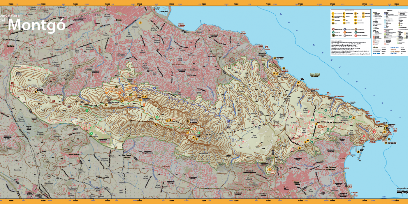
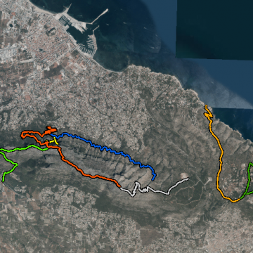
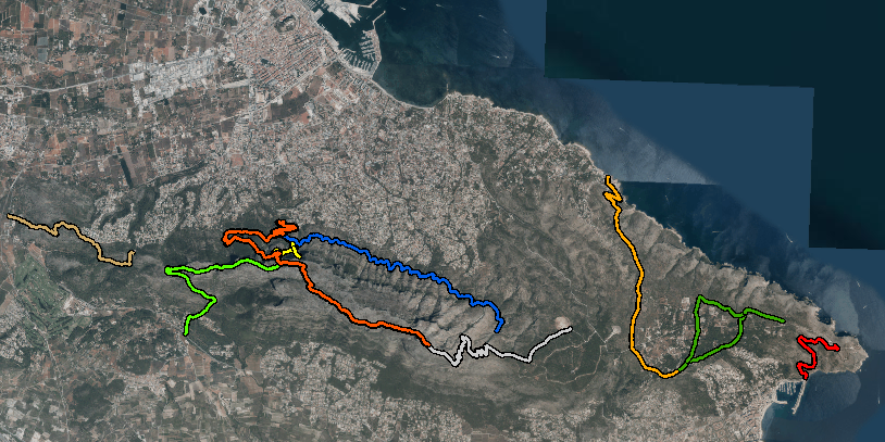
Different routes of varying difficulty levels to discover Montgó
Description
Description
The Montgó Natural Park offers a variety of hiking trails that allow you to explore its rich biodiversity and breathtaking landscapes. These trails vary in difficulty and duration, so it is important to choose the one that best suits your abilities and the time you have available.
ROUTE 1: End of Les Rotes – Port of Xàbia: This is not a marked route as such, as it combines three of the park's official routes, connecting the Les Rotes area in Dénia with the port of Xàbia and offering spectacular coastal views and numerous examples of rural architecture from centuries past.
ROUTE 2: Camí de la Colònia – Cova del Gamell: This route starts at the Ermita del Pare Pere chapel and heads towards the Cova del Gamell cave, taking approximately 1 hour and 20 minutes one way. It is a moderately difficult route.
ROUTE 3: Cova de L'Aigua – Racó del Bou: This route leads to the Cova de L'Aigua and Racó del Bou, allowing you to explore rock formations and natural caves.
ROUTE 4: Jesús Pobre – Summit: Starts at Jesús Pobre and ends at the summit of Montgó, 753 metres above sea level. This route is longer and more challenging, with an estimated duration of 3 hours and 45 minutes.
ROUTE 5: Torre del Gerro – Molins: Starts at Torre del Gerro in Dénia and ends in Xàbia, with an estimated duration of 55 minutes. This route offers panoramic views and passes by several historic mills
ROUTE 6: Shooting Range – Summit: One of the most complete and longest routes, leading to the summit of Montgó. It is recommended for experienced hikers due to its length and elevation gain.
Recommendations:
- Access to Cova Tallada requires advance booking, as access is limited. The booking process is carried out through the official website of the Valencian Regional Government's Natural Parks:
https://parquesnaturales.gva.es/es/web/pn-el-montgo/
- Choosing the best time of year: The best time to hike the Montgó trails is during spring (March to May) and autumn (October to December), when temperatures are pleasant and the vegetation is in full bloom, enhancing the beauty of the landscape. On the other hand, summer (June to September) should be avoided due to high temperatures, which can make hiking dangerous, especially in the middle of the day. Be cautious in winter (December to February), as conditions can be cold and wet, and some routes can become slippery. It is always important to check the weather forecast before setting out and avoid routes on days with heavy rain or storms.
- Choose the right route: The Montgó routes vary in difficulty. Be sure to select an itinerary that suits your level of fitness and experience. The longer routes with greater elevation changes are recommended only for experienced hikers.
- Be properly equipped: The terrain is rocky and there is little to no shade on many routes. Wear comfortable footwear suitable for hiking, preferably hiking boots. There are no water sources in the park, so bring enough water, a hat, sunglasses and sunscreen.
- Follow the marked trails: It is essential to stay on the marked trails to protect the park's flora and fauna, which includes protected species.
- Check the weather forecast: Before setting out, check the weather to ensure that conditions are safe for hiking.
- Respect the environment: Do not pick plants or disturb animals. It is prohibited to leave the trails and take shortcuts, which increase erosion of the fertile soil. Keep the park clean and follow the conservation guidelines.
- Plan your time: Some routes can take several hours, so make sure you have enough time to complete the hike and return before dark.
- Bring a map or use hiking apps: Familiarise yourself with the area and the available routes. This will help you find your way during the hike.